 As I try to refrain from The Lovin' Spoonful references, I have to say that lately I've been feeling more and more at home living in the city. I love summer in Brussels, because all the plebs that live outside the pentagon bugger off on their holidays and the city centre turns into one amazingly friendly village (so long as you ignore the tourists).
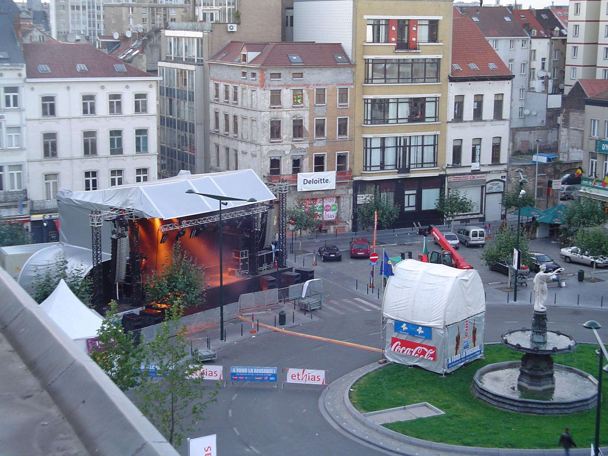
Brussels also comes alive in a certain indefinable magic way, not only because it has it's own beach on the canal, or the arrival of the carnies at the medieval city gate in the south, but because of a fantastic summer festival.
This year, the festival has come to my doorstep!
Since yesterday, which I might add was a public holiday, crews have been working hard to turn my square into a concert venue, with the stage being built in twelve hours yesterday and the rigging done today. I have a pretty good vantage point, since the stage points mostly in the direction I face when I chill out on my window sill.
This will be interesting, since by the time I plan to get home on Sunday, I'll be confronted with «Les Fatals Picards», the French entry to this year's Eurovision song contest, with whom I apparently failed to see the humour of. I'm secretly hoping Tom's correct in saying it's the other Fatals Picards that were mildly popular in the 1980s in the UK. I'm also hoping they're not one and the same.
After them are the crazy, yet unique, French punk band, «Les Wampas», who will probably continue to do more harm to my already horrible French.
With so much going on around me, it's almost impossible to keep track. I think I miss out on a lot of what's going on because I commute to work underground in the metro. This is something I've been thinking of changing, especially since John's hard-slog back in May. Despite all the talk about wanting to go running, I just don't seem to have the motivation.
Since my brush with Cyclocity back in June, I've been preoccupied to the point where I haven't been able to do anything other than ponder if I should buy my own bike, or a yearly subscription to Cyclocity. I feel quite limited by the Cyclocity stations, but think it's easier than finding a place to store my own bike.
To cover both running and cycling, and to feed my inner-geek, I went off a bought a Garmin Forerunner 305, mostly because a colleague in the USA recommended it a long time ago. In fact, Mr. Giordanelli swears by his 205, the older model, but I really wanted a heart-rate monitor. I took it on its maiden voyage last Sunday with Al for a small test on an unplanned route at a very relaxed pace; but more on that another day.
Now I'm thinking it's possible for me to cycle to work, so long as I buy a decent bike with good coverage of low gears. I live in a bit of a valley, and most of my morning commute would be up-hill. I presently walk in the mornings to help wake me up, and I think this would replace the morning coffees. Surprisingly, I'm more motivated to cycle to work than to run, despite the fact that this Summer has been more of an Autumn.
Will I still have the motivation to cycle to work as it gets colder, and will I have the want to spend the money?
It's a pity that the days can't be like the nights, in the summer, in the city… in that I wouldn't have to go to work. Errm, sorry about that, it's stuck in my head now.
How the hell can you wheeze like a bus stop, anyway?
Comments
AMC #
AMC #
John #
Simon Butcher (Author) #
John #
Commenting has expired for this article.